


في Drone Tech، نقدم بيانات جوية دقيقة، ورؤى أكثر ذكاءً، وعمليات أكثر أمانًا من خلال تقنيات الطائرات بدون طيار المتقدمة. تشمل مجموعة تقنياتنا — على سبيل المثال لا الحصر — نمذجة التوأم الرقمي لقطاعات الهندسة والعمارة والبناء (AEC) والمدن الذكية، وتقنية LiDAR للبنية التحتية والمرافق، والتصوير الحراري والفوتوغرامتري لقطاعات الطاقة والنفط والغاز، وأجهزة الاستشعار متعددة الأطياف للزراعة وغيرها من أعمال الفحص.
ومن خلال دمج هذه الإمكانات، نقدم حلولًا متكاملة تشمل أعمال المسح ورسم الخرائط، وعمليات التفتيش، وإدارة الأصول، مما يمكّن المؤسسات من تحسين الأداء، وتقليل المخاطر والتكاليف، وتسريع التحول الرقمي.
خرائط أورثوموزايك جغرافية المرجعية بدقة على مستوى السنتيمتر للتخطيط والتصميم والتوثيق.
سُحب نقاط عالية الكثافة تخترق الغطاء النباتي لكشف الارتفاع الحقيقي للأرض، بدقة أفضل من الفوتوغرامتري.
خطوط ارتفاع دقيقة، ونماذج رقمية للتضاريس (DTMs)، ونماذج رقمية للأسطح (DSMs) لمشاريع تطوير الأراضي والبنية التحتية.
إنشاء نماذج ثلاثية الأبعاد دقيقة للأصول لإدارة دورة حياتها، والصيانة التنبؤية، والتفتيش عن بُعد.
تقديم مجموعات بيانات جغرافية مكانية تُدمج بسلاسة في منصات إدارة الأصول.
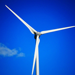
تحويل بيانات التفتيش إلى نماذج ثلاثية الأبعاد للصيانة التنبؤية وإدارة دورة حياة الأصول.
سُحب نقاط دقيقة ونماذج ثلاثية الأبعاد للتحليل الهيكلي وكشف التشوهات.
الوصول إلى المناطق صعبة الوصول مثل الخزانات والمداخن والصوامع دون تعريض الأفراد للخطر.
تحديد التغيرات في انعكاس الضوء عبر الأطوال الموجية المختلفة (RGB، الحافة الحمراء، الأشعة تحت الحمراء القريبة NIR، والأشعة تحت الحمراء قصيرة الموجة SWIR).

Social List